
CHUGOKU
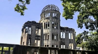
Atomic Bomb Dome: The bomb detonated approximately 600m above the city — roughly 160m horizontal from the Dome. The near-vertical blast left the vertical walls standing while destroying every horizontal surface. That structural coincidence is the main reason it survived. UNESCO World Heritage 1996. Give the Peace Memorial Museum three hours minimum.
Miyajima: 10-minute ferry from Miyajimaguchi. The camphor-wood torii is the eighth iteration since the 12th century — this one raised in 1875. The island historically prohibited births and deaths on its soil.
-
Itsukushima ShrineWalk out to the torii at low tide; check tide times. Small island visitor tax.📍 Google Maps
-
Onomichi & Shimanami KaidoHillside temple town and start of the island-hopping cycle route.📍 Google Maps
-
Ōkunoshima"Rabbit Island" by 15-min ferry; its Poison Gas Museum tells the wartime story.📍 Google Maps
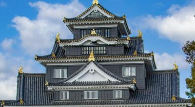
Korakuen: One of Japan's three great gardens — an Edo-period ranking that predates tourism. Construction started 1687, took 14 years, and the design has changed relatively little since. The black-walled "Crow Castle" rises just across the Asahi River — its keep a 1966 reconstruction of the original lost in 1945.
Kurashiki: The white-walled canal-side storehouses were preserved largely through local efforts led by the Ohara family. The Ohara Museum of Art (1930) was Japan's first museum of Western art — its Monet Water Lilies was bought directly from the artist at Giverny.
-
KorakuenOne of Japan's Three Great Gardens, with lawns, ponds and a borrowed castle view.📍 Google Maps
-
Okayama Castle"Crow Castle" across the river from Korakuen; reconstructed keep with views.📍 Google Maps
-
Kurashiki BikanWhite-walled storehouses along a willow-lined canal. Take the small boat ride.📍 Google Maps
-
Ohara Museum of ArtJapan's first Western art museum: Monet, El Greco and more, in Kurashiki.📍 Google Maps
-
Bitchu Matsuyama CastleHighest of Japan's 12 original keeps. Short steep hike; "castle in the sky" mornings in autumn.📍 Google Maps
-
Kibi Plain Cycling RouteFlat ride past ancient tombs to Kibitsu Shrine, home of the Momotaro legend.📍 Google Maps
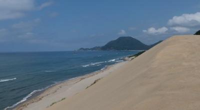
Tottori Sakyu: 16km along the Japan Sea coast, 47m at the tallest ridge. The wind reshapes the surface daily, and volunteers pull invading plants to keep the dunes from shrinking. Japan's least-populous prefecture, and on a weekday in spring the main ridge is yours.
Sand Museum & Uradome: International sand sculptures around a new theme each year (closed for a few months while it's rebuilt). Uradome Coast runs sea kayaking through sea caves in water clear enough to track fish from the surface — a short bus ride east of the dunes.
-
Tottori Sand DunesClimb the Uma-no-se ridge for Japan Sea views; best at sunrise or sunset.📍 Google Maps
-
Sand MuseumGiant sand sculptures on a new theme each year. Check dates; it closes to rebuild.📍 Google Maps
-
Mitokusan NageiredoTemple hall built into a cliff face. Steep, rough climb; proper shoes, no solo hikers.📍 Google Maps
-
Hakuto ShrineMatchmaking shrine by Hakuto Beach, tied to the White Rabbit of Inaba legend.📍 Google Maps
Izumo Taisha: All eight million Shinto deities are said to gather here in the tenth month of the old lunar calendar (around November today) — the month Izumo calls "with gods." Dedicated to Ōkuninushi, god of marriage. The shimenawa rope at the Kaguraden is the largest in Japan.
Adachi Museum: Ranked first in the Journal of Japanese Gardening every year since the survey began in 2003. You view the garden rather than walk in it, often framed by the museum's windows — the building treats it as a living painting. In Yasugi, not Matsue.
-
Izumo TaishaPray the Izumo way: two bows, four claps, one bow. See the giant rope at the Kaguraden.📍 Google Maps
-
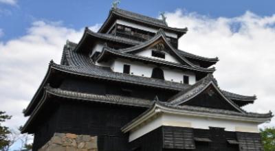
Matsue CastleNational Treasure and one of Japan's 12 original keeps; take the moat boat.📍 Google Maps
-
Adachi Museum of ArtJapan's top-ranked garden, viewed from inside the museum. In Yasugi.📍 Google Maps
-
Lake Shinji SunsetOne of Japan's classic sunsets, from the lakeshore by the Shimane Art Museum.📍 Google Maps
-
Yuushien GardenPeony garden on Daikonshima island, reached by causeway; peak bloom late April–May.📍 Google Maps
Kintaikyo: First built 1673 — five wooden arches leaping between four stone river piers, strengthened after the first bridge washed away in 1674. It then stood until a 1950 typhoon, and was rebuilt in 1953 using traditional wooden joinery.
Hagi: Castle town that produced Itō Hirobumi (Japan's first Prime Minister), Yamagata Aritomo, and Kido Takayoshi — all from the same Edo-period streetscape you can still walk today. Its sites, including Yoshida Shōin's Shōka Sonjuku school, are UNESCO-listed.
-
Akiyoshido CaveOne of Japan's largest limestone caves, under the Akiyoshidai karst plateau.📍 Google Maps
-
Motonosumi Shrine123 red torii down a cliff to the sea. Try landing a coin in the high offering box.📍 Google Maps
-
Hagi & Shōka SonjukuSamurai lanes, Hagi pottery and the UNESCO-listed school that shaped Meiji Japan.📍 Google Maps